

File:Nellis Air Force Base, Las Vegas, Nevada (14017031619).jpg

Original file (4,000 × 3,000 pixels, file size: 6.75 MB, MIME type: image/jpeg)
.jpg)
Summary
| Description |
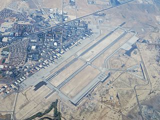
Nellis Air Force Base is a United States Air Force base located in North Las Vegas, Nevada. It is seven nautical miles (13 km) northeast of the central business district of Las Vegas. It was named in honor of P-47 pilot 1st Lieutenant William Harrell Nellis, who was killed in WWII during the Battle of the Bulge. An installation of the Air Combat Command (ACC), Nellis is the location of the United States Air Force Warfare Center and is a major training location for both U.S. and foreign military aircrews. The main base covers approximately 11,300 acres (4,600 ha). Sixty-three percent of it is undeveloped, while the remaining area is either paved or contains structures. The base consists of three major functional areas. Area I includes the airfield and most of the mission support functions. Area II is east of Area I and contains the munitions area. Area III is across Las Vegas Boulevard from Area I. It contains housing, Mike O'Callaghan Federal Hospital, and open space. The associated Nevada Test and Training Range is located to the west in Nye and several other counties. en.wikipedia.org/wiki/Nellis_Air_Force_Base |
| Date | |
| Source | Nellis Air Force Base, Las Vegas, Nevada |
| Author | Ken Lund from Reno, Nevada, USA |
| Camera location | | View this and other nearby images on: OpenStreetMap |
|---|
.jpg¶ms=036.232582_N_-115.035974_E_globe:Earth_type:camera_source:Flickr_&language=en)
Licensing
- You are free:
- to share – to copy, distribute and transmit the work
- to remix – to adapt the work
- Under the following conditions:
- attribution – You must give appropriate credit, provide a link to the license, and indicate if changes were made. You may do so in any reasonable manner, but not in any way that suggests the licensor endorses you or your use.
- share alike – If you remix, transform, or build upon the material, you must distribute your contributions under the same or compatible license as the original.
| This image was originally posted to Flickr by Ken Lund at https://flickr.com/photos/75683070@N00/14017031619. It was reviewed on 4 December 2015 by FlickreviewR and was confirmed to be licensed under the terms of the cc-by-sa-2.0. |
File history
Click on a date/time to view the file as it appeared at that time.
| Date/Time | Thumbnail | Dimensions | User | Comment | |
|---|---|---|---|---|---|
| current | 01:00, 4 December 2015 | | 4,000 × 3,000 (6.75 MB) | wikimediacommons>INeverCry | Transferred from Flickr via Flickr2Commons |
File usage
The following page uses this file:
.jpg)